
|
| "Imagine a trail that winds completely around the most spectacular lake in the United States. As you ride along the 170 mile trail you meander through areas rich in Basque History, where some of the west's first Basque Sheep Herders roamed with their flocks through mountain meadows over 100 years ago... you wade through waist-high grass, large groves of aspens, through magnificent stands of red fir and ponderosa pine and stop to drink from cool mountain streams, sweet to the taste... the trail wanders through old Washoe Indian grounds and long vanished game trails... as well as trails made by early settlers fresh from obtaining the air provisions from Nevada's first settlement at Genoa. You may wander high above mysterious places with names like "Hellhole" with its many small pools and ground that shakes, rolls and sways... you skirt the largest Bog in the Sierra at Grasshole... and most of the time you are able to view the highest and largest alpine lake in North America, Lake Tahoe, on the horizon....The Pine Nut Range in Nevada, the Sierra of California, the Carson Valley.... you travel through six counties, three National Forests, and two States... a week and a half later you are back where you started" - Glen Hampton, U.S. Forest Service Supervisor. |
The following is a diary of a ten day Heritage Trail Fund Ride in mid-August 1996 as it was experienced by a party of four riders riding three Peruvian Paso horses (CBB Alcalde, Banquero RCD & ERB Relebo) and one Arabian horse. Forty-five riders from five states started this ride with eighteen completing the full ten day distance of 170 miles. |
| 1996 Tahoe Rim Trail Ride |
|
Ride day - Minus One: Last minute struggle to remember all our needs for the next ten days - worse yet is trying to find room for it all - how to package it. We had to resurrect an old back pack for additional luggage - it went like this: two - 1/2 bale hay bags: one for horse stuff, one for tent, sleeping bags, etc.; one - small brief case - grooming equipment; one - large duffel bag for clothes; one - back pack - for misc. overflow items; one - small duffel bag - for clothes; one - large brief case (aka: Bar) Travel starts at 10:30 a.m. - camper, horse trailer with horses - We caravan with Dan and Cheri Capestro, stop at Sam's Town to hook up with Tom and Sandy - where the CB radio would not connect at some 1/4 mile distance - travel up highway 50 was uneventful.
Instructions for the a.m. were - Breakfast at 6:30 a.m. - First ride unit out at 8:00 a.m. - Second unit out at 8:30 a.m. - Third unit out at 9:00 a.m. (approximately 14 riders per unit). Everyone makes their own lunch (sandwich makings and snacks provided) - All luggage must be loaded on truck for transport to next evening's camp site. |
|
Day One: Off we are at 8:00 a.m. (second group) lead by Nancy Dupont (Secretary of Heritage Trail Fund). Within a 1/4 miles we hit the Pacific Crest Trail (PCT) traveling south through mature red fir forest - over, through and around the large white gray granite outcroppings - through Benwood Meadows. Along the trail were magnificent old old juniper trees, twisted and gnarled by the harsh winter climate.
Lunch at Showers Lake was welcome, well populated with Back Packer Campers. We watched kids jump off the rocks into the ice cold snow fed water, their screams would echo the cold they felt - none of our group approached the water. After lunch we continued south on PCT to Meiss Meadows for a couple miles where we turned Northeast on the Tahoe Rim Trail (TRT) and watered the horses in the head waters of the upper Truckee River. Most of us don't think of the Truckee River extending beyond or upstream from Lake Tahoe.
Upon arriving at Highway 89 we had our first experience of a mass crossing in an area of high speed auto travel - all went well. Except - our group leader became lost after the highway crossing - unable to locate the campsite - most of us found this amusing. Camp was not far from this highway next to a small stream (elevation 7500 ft.). This was our first effort to set up camp. First to select the best available site (it's a race against the other 40 people!). Second - to find your luggage amongst the other 40 people's luggage that had been thrown off the truck into one big pile. Third - to take care of the horses, water, feed, blanket, opt to tie to community high line or to put up your own high line. For two of our three Peruvian Paso horses it was their first experience being secured in this manner and all handled it without difficulty.... Fourth - Set up tent and sleeping bags, etc. in time to enjoy the hors d'oeuvres offered by the caterer, washed down with those "essential" minerals and spirits to relax the mind and body and to reflect on 18 miles of beautiful trail being the first day of this 10 day adventure. All three of our Peruvian horses, being in good condition prior to the ride, took that first day well. Parts of the trail were very rocky and steep - each horse excelled in the rough going. There were several participants who chose not to continue due to lack of proper conditioning, lameness, unable to control their horse because of the size of the group or due to trail conditions. During the campfire activities we were told about their standard operating procedures, that with the horses, most being secured to the long common high line, they would have a Night Watch. Individuals were assigned one hour watches spanning from 10:00 p.m. to 4:00 a.m.. Selection was done alphabetically - yes, we both got first night "night watch", midnight to 2, checking on the horses each half hour, looking for loose horses, tangled horses, and sagging or down high line. This activity initially was looked upon as a curse, in actuality it was a very pleasant experience, sitting next to the campfire in complete stillness, watching the star filled sky complete with shooting stars - very romantic and peaceful. |
|
Day Two: Starts when the first horse gets fed - all the rest of the horses begin to knicker and call for breakfast - if not attended to, the noise gets louder with bucket kicking and pawing. So, first feed and water horses, then begin to fold up camp - packing all gear and load on the truck, make lunch - after the first day we learned that this was a priority item, if one delays in fixing lunch all the good fixin's and snacks are gone. Breakfast was usually lots of scrambled eggs with anything that was left over from the night before chopped and mixed with the eggs, lots of ham and bacon and biscuits, with gravy for some.
We had a nice campfire with George Cardinet's pioneer stories about competing travel routes, Tahoe to Carson Valley, being Armstrong Pass and Dagget Pass now known as Kingsbury Grade to the North (our destination on tomorrow's ride). At each campsite, they set up what is called the "Golden Throne". This is a 5 gallon round can, no bottom, with a toilet seat bolted to it. - all painted gold. This contraption is placed over a hole or pit, surrounded by a cloth drape over a metal frame which provided "limited" privacy for camp toilet needs. |
|
Day three: Greets us at day break with smoke cover in the canyon that blots out the sun. At breakfast the cook comments "I really didn't think we had that big a campfire last night." Later, we learned there were some eight forest fires burning from Carson City to Yosemite. During the next 6 days the smoke cut most of the distant views. This day we were asked to ride with group one as there were reports of some downed trees across the trail and they would need help possibly to drag the logs off the trail. As it turned out we were able to go around these downed timbers. Some of these detours were steep and slide-like but our horses tackled their path with ease and all survived, even those with eyes closed.
As we climb, lodge pole pines gave way to sage brush, some aspens, and western white pine. We climb to a Saddle (9600 ft.) at the foot of Freel Peak (10881 ft.). Freel Peak along with Job's Sister (10823 ft.) are the highest peaks in this area. Few trees at this elevation - some ancient white bark pines. The landscape has lots of open areas of just decomposed granite. After a rest and a chance to absorb the panorama, we head down hill for the first time today, switch back and forth then up and over a ridge, then dropping down to Star Lake where we found the trail disappearing into the lake. The lake's exit had been closed by a large log jam that raised the lake water level. We had to move the outer most logs to clear a way for our horses and then convince the horses to move through 4 foot deep water for about 50 feet - this was one of the high points in this days' adventure. Another 3-1/2 miles of traversing the very steep side hill topography brings us to 9000 ft. Monument Pass just prior to the California/Nevada border. Here we lunched and rested our horses. From Monument Pass the trail moves to the east side of the Tahoe Rim Water Shed that gave us views down into the southern end of Carson Valley, but the forest fire smoke was still so thick that we could only see the first mile or so of the valley. This five mile section of the TRT drops to about 7200 ft. elevation. After traveling almost 30 miles in the last 2 days through this beautiful mountain ridge- top rail without encountering civilization we were startled to look up and see ski lifts over head. These were part of Heavenly Valley Ski Operation. They have lifts up from the Tahoe Basin then one could ski over the edge away from Tahoe then take the lift back up to the top. It was those lifts over the top to the East that our trail ran under.
Third night camp found us at Boulder Ski Lodge on Dagget Pass just off Highway 207 or Kingsbury Grade. Bolder Ski Lodge is a small local ski operation. We pitched our tent on pavement in front of the ski rental/ repair department. We had full run of the lodge (it was closed for business of course - no skiing in August.) For a shower it was a two part deal - upstairs to the Bar to wash my hair in the bar sink, rinse with the multi-buttoned pressurized drink dispenser (no hot water). For the rest of the bath I heated a bucket of water on our one burner propane stove and took it to the inside restroom and took a sponge bath in the handicap stall. That's the closest I have ever come to being "homeless". This day's travel was 18 miles with lots of climbing. All noticed the affects of the 9000 ft. altitude on out selves as well as the horses. There were some other rider drop outs this day but no serious horse problems. Our horses took it all in stride, we were especially proud of their willingness at the Star Lake water crossing. This was the first time we have high lined our horses on the community high line as we had been chased out of the only other places to tie horses. We did make an effort to assure that neighboring horses were compatible - all went well overnight. The Ski Run At this time of year was all in high grass. Owen Cardinet (George Cardinet's son and leader of group one) chose to treat his horse along with a second horse to some of the lush vegetation - one horse was hobbled and the other was reported to always stay with his stable mate and didn't need to be hobbled - well guess what? Something spooked the horses , the hobbles broke and the 2 horses were off to the race up the ski run (5000 ft.) and over the hill at a full gallop. This all happened at about 6:00 p.m.. Owen quickly begged a bystander's horse (which had to be quickly tacked up) along with Brenda Ruedy (a National Champion Endurance Rider), took off after the loose horses. Everyone speculated; who would lead group one on the ride because they knew Owen would never find his horse, having had a very good head start and the limited amount of daylight left to search. At bedtime (maybe 10:30 p.m.) the search report was that there had been no horse sighting and that they were continuing back down the trail we had traveled today. This evening we had a nice dinner, able to sit on tables and benches on the second level deck of the ski lodge and enjoyed another pioneer history lesson from George Cardinet. |
|
Day four:
About 5 miles out we could hear the loud air craft engines and soon we could see the large twin rotor helicopter going back and forth across the horizon. As we got closer one could see a long line dangling down - then on a return trip attached to the line was a bundle of maybe 12 to 15 logs. It took this machine about 4 minutes to round trip with a load of logs. The ride sponsors had been cautioned that the TRT would be closed during the logging operation so a detour had been planned. This would take us on logging roads by-passing the helicopter logging. There was considerable trouble locating the detour. Needless to say the aesthetics of this route were not comparable to those along the TRT. This was the second day we rode with group one (we thought there would be an advantage to being into the camp first - we would have a better choice of camp sites, etc.) As it turned out, group one traveled so slow the other groups would catch up by noon.
As we came back onto the trail near Duane Bliss Peak, we caught views down into the smoke filled canyon, Eagle and Washoe Valleys, and could see the devastation caused by the Genoa fire earlier this season. Spooner Summit camp site was at the rest stop and picnic area next to Highway 50. We again tethered the horses on the community high line. After dinner we had a long history talk by U.S. Forest "Ranger Roy". It was noticed that some attendees were lulled into complete relaxation, catching some zzz's but polite enough not to snore. Highway traffic noise during the night would interrupt ones sound sleep. |
| Continued on page 2 |
 Arrival at Echo Summit Ski Area
(altitude approx. 7400 ft.) about 2:00 p.m. required leaving
horses tied to trailer on pavement. By 3:00 p.m. it became overcast,
dark and cold. Much loud thunder followed by heavy rain and large
hail stones (a typical mountain thunder storm) - the horses were
bothered particularly by the hail stones - they acted as if someone
were throwing small rocks at them - the storm passed over prior
to our first catered meal. After a fine pork steak cowboy meal
we were afforded a history talk by our trail boss and Heritage
Trail patriarch, George Cardinet, age 87, which included information
on pioneer trail routes over Echo summit, Pony Express, etc.
Arrival at Echo Summit Ski Area
(altitude approx. 7400 ft.) about 2:00 p.m. required leaving
horses tied to trailer on pavement. By 3:00 p.m. it became overcast,
dark and cold. Much loud thunder followed by heavy rain and large
hail stones (a typical mountain thunder storm) - the horses were
bothered particularly by the hail stones - they acted as if someone
were throwing small rocks at them - the storm passed over prior
to our first catered meal. After a fine pork steak cowboy meal
we were afforded a history talk by our trail boss and Heritage
Trail patriarch, George Cardinet, age 87, which included information
on pioneer trail routes over Echo summit, Pony Express, etc.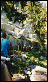 Each group
had an arranged leader and drag rider. We found ourselves lagging
behind - a result of stopping to take pictures - this allowed
us to then move ahead at a fast gait, catching up with the others
who seldom seem to move faster than what we would call a slow
walk. The trail is single track climbing up to 8900 feet by mid-morning
into lodge pole pine and Mt. Hemlock open forest. As we near
our lunch stop at Showers Grove we looked down on an open area
sparsely treed and covered with a Bloom of Spring, wildflowers
fed by large snow banks high above at the skyline. The trail
crossed this open area of many streamlets and flowered odyssey.
The rock formations changed with granite below and sizable, very
dark volcanic outcroppings above.
Each group
had an arranged leader and drag rider. We found ourselves lagging
behind - a result of stopping to take pictures - this allowed
us to then move ahead at a fast gait, catching up with the others
who seldom seem to move faster than what we would call a slow
walk. The trail is single track climbing up to 8900 feet by mid-morning
into lodge pole pine and Mt. Hemlock open forest. As we near
our lunch stop at Showers Grove we looked down on an open area
sparsely treed and covered with a Bloom of Spring, wildflowers
fed by large snow banks high above at the skyline. The trail
crossed this open area of many streamlets and flowered odyssey.
The rock formations changed with granite below and sizable, very
dark volcanic outcroppings above. The next
major feature was Round Lake surrounded by dark volcanic rock
with steep cliffs to the east. The Trail became very rough and
steep downgrade between Round Lake and Big Meadows where we rode
among the many fat beef cattle feasting on the lush meadow.
The next
major feature was Round Lake surrounded by dark volcanic rock
with steep cliffs to the east. The Trail became very rough and
steep downgrade between Round Lake and Big Meadows where we rode
among the many fat beef cattle feasting on the lush meadow.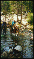 This routine
of up at 5:30 a.m. , feed horses, pack and load all gear, eat
breakfast, make lunch, groom self and horses, tack horses and
be in the saddle and on the trail by 8:30 a.m. was taxing, but
off we go headed for Armstrong Pass through some beautiful open
Jeffrey pine forests with some striking large granite rock outcroppings.
The trail was part of a newly constructed section, having excellent
tread complete with cut granite stair facings - all reasonable
grades not exceeding 10%. We climbed from 7500 ft. to 8900 ft.
elevation. We lunched at Freel Meadows.
This routine
of up at 5:30 a.m. , feed horses, pack and load all gear, eat
breakfast, make lunch, groom self and horses, tack horses and
be in the saddle and on the trail by 8:30 a.m. was taxing, but
off we go headed for Armstrong Pass through some beautiful open
Jeffrey pine forests with some striking large granite rock outcroppings.
The trail was part of a newly constructed section, having excellent
tread complete with cut granite stair facings - all reasonable
grades not exceeding 10%. We climbed from 7500 ft. to 8900 ft.
elevation. We lunched at Freel Meadows.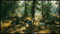 Near the
top we had some marvelous views - North to Tahoe and down into
what is called "Hellhole". To the south, the spectacular
sky line beyond Hope Valley and Caples Lake. The day's ride is
short , 10 miles, simply because the next day will be very long.
The only available place they are able to get the truck, kitchen
and all in is a 1000 ft. drop down from Armstrong Pass, to the
south, camping on a tributary of Willow Creek. Setting up camp
was a little easier the second day.
Near the
top we had some marvelous views - North to Tahoe and down into
what is called "Hellhole". To the south, the spectacular
sky line beyond Hope Valley and Caples Lake. The day's ride is
short , 10 miles, simply because the next day will be very long.
The only available place they are able to get the truck, kitchen
and all in is a 1000 ft. drop down from Armstrong Pass, to the
south, camping on a tributary of Willow Creek. Setting up camp
was a little easier the second day.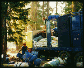 We
had taken a "Sun Shower" hot water system complete
with plastic enclosure. We heated water on a one burner propane
stove. After much trial and error we learned how to fill the
water bag without spilling or burning ones hands and we learned
how to hang the enclosure - only one shower completed - should
have been four. We had been told that the Truck/Cook crew would
put the bag out into the sun to heat upon arrival at each camp
if we would fill the bags in the a.m. for transport on the truck.
Unfortunately they never seemed to get into the sun.
We
had taken a "Sun Shower" hot water system complete
with plastic enclosure. We heated water on a one burner propane
stove. After much trial and error we learned how to fill the
water bag without spilling or burning ones hands and we learned
how to hang the enclosure - only one shower completed - should
have been four. We had been told that the Truck/Cook crew would
put the bag out into the sun to heat upon arrival at each camp
if we would fill the bags in the a.m. for transport on the truck.
Unfortunately they never seemed to get into the sun.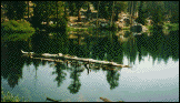 So up the 1000
ft. climb from camp to Armstrong Pass, 8900 ft. elevation, and
north on TRT. A good trail with constant climb across a very
steep side hill. We had been alerted by our group leader that
there were some large crystals found along this section of the
trail. It appeared that some were on and off their horses loading
saddle bags with precious stones but I can't remember anyone
showing off their recent finds.
So up the 1000
ft. climb from camp to Armstrong Pass, 8900 ft. elevation, and
north on TRT. A good trail with constant climb across a very
steep side hill. We had been alerted by our group leader that
there were some large crystals found along this section of the
trail. It appeared that some were on and off their horses loading
saddle bags with precious stones but I can't remember anyone
showing off their recent finds.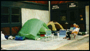 From
there it was only a short distance to our camp for the night
- our route turned from single track trail to logging roads.
From
there it was only a short distance to our camp for the night
- our route turned from single track trail to logging roads.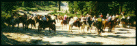 From Dagget Pass or Bolder Ski
Lodge to the TRT trail head is about 2 miles of urban area -
homes, cabins, all roads paved, no trail, so as a single unit
all 34 horses traveled on pavement, in and around cars and traffic.
Our destination today is Spooner Summit (highway 50). From the
TRT assembly area at the end of Andrea Drive, the trail travels
through some beautiful ponderosa forest - the trail is excellent.
From Dagget Pass or Bolder Ski
Lodge to the TRT trail head is about 2 miles of urban area -
homes, cabins, all roads paved, no trail, so as a single unit
all 34 horses traveled on pavement, in and around cars and traffic.
Our destination today is Spooner Summit (highway 50). From the
TRT assembly area at the end of Andrea Drive, the trail travels
through some beautiful ponderosa forest - the trail is excellent.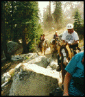 We
also found that there was a different sort of posture, power
and procedure emanating not from the leader but from the drag
rider. He kept the group closely bundled and dictated who rode
in what line position. And barked out and scolded in front of
all if you didn't follow all his rules. After two days of this
we deserted group one and pinned a handle on this drag mule rider
as the "last Ass".
We
also found that there was a different sort of posture, power
and procedure emanating not from the leader but from the drag
rider. He kept the group closely bundled and dictated who rode
in what line position. And barked out and scolded in front of
all if you didn't follow all his rules. After two days of this
we deserted group one and pinned a handle on this drag mule rider
as the "last Ass".