Day five:
The first chore of the day was to check the horses, to find 2 of our horses and one lead rope still tied to the high line but no horse - the lead rope had been chewed though. As I searched for Relebo all sorts of bad images went through my mind - but that was short lived. Relebo was about 15 feet away, not about to stray too far from his friends. You see, part of the pre-ride instructions were to have 12 ft. x 5/8 inch cotton rope leads, which we found to be very palatable to Relebo.
The fifth day's ride took us immediately across Highway 50 and on to a relatively new trail.
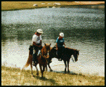
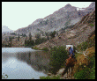
We looked down onto Spooner Lake. Traveling north we climb from 7146 ft. elevation to 9000 ft. where we could look down to beautiful Marlette Lake with a back drop of Lake Tahoe at a lower elevation. At this open summit we found ourselves on a carpet of purple/blue Lupen. It was like the top of the world even though the forest fire smoke continued to hide the west shore of Lake Tahoe.
Not far down the trail we began to see old weathered stumps cut 9 to 12 feet above the ground. It would have taken some awful tall logger to cut these trees at that level. Later we were told that these trees were cut during the winter while standing on huge snow drifts. The logs were used as timbers for the mines in Virginia City during the Comstock Silver Rush of the 1860's. A water system was also developed during that era, taking water from Marlette Lake via flume and siphon to Virginia City - it's still in service today.
 The
sight of Twin Lakes was welcomed by the horses as there had not
been any water since camp at Spooner Summit. Traveling now on
jeep roads, just beyond Twin Lakes there came some indecision
as to which way to proceed. Owen scouted a route down the hill
towards the Ponderosa Ranch. The other option was to the right
on the Capitol to Capitol Trail. It became obvious that no one
had pre-ridden the trail since their last Tahoe Rim ride some
4 years ago,
The
sight of Twin Lakes was welcomed by the horses as there had not
been any water since camp at Spooner Summit. Traveling now on
jeep roads, just beyond Twin Lakes there came some indecision
as to which way to proceed. Owen scouted a route down the hill
towards the Ponderosa Ranch. The other option was to the right
on the Capitol to Capitol Trail. It became obvious that no one
had pre-ridden the trail since their last Tahoe Rim ride some
4 years ago,
Down the hill we go then turned up a gully following an old faint trail. Soon it did intersect with a new section of the TRT that had not been yet connected to our last point of indecision. This fine new trail lasted about 2 or 3 miles - we had come again to a point where the TRT was yet to be built. So off we went, cross country, there were some old ribbons but soon those also disappeared or we got off on another route.
Group one and two were now one group.
We were chosen to go back and advise group three not to take
down the ribbons that had just been put up as we may have to
go back. So up, down, over, around,sometimes we go back and try
another route, but that's the fun of cross country travel. The
only fear is that one can't find a way through. After quite some
distance we did again come across some brand new trail work including
a camp with tents and trail making equipment. 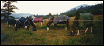 Shortly,
we arrived at Tahoe Meadows, crossed the Mt. Rose Highway to
a hillside meadow called Camp (8553 ft. elevation).
Shortly,
we arrived at Tahoe Meadows, crossed the Mt. Rose Highway to
a hillside meadow called Camp (8553 ft. elevation).
This was a suitable camp excepting the highway traffic noise all night. We again tied the horses to the Community high line. In the morning we found two of our horses tied to a small tree. Apparently the high line had come down during the night and they had not bothered to put our horses back on that high line.
Day Six:
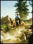
We find ourselves at the north end of Lake Tahoe, setting off west on graveled roads for a short distance, then some sharp climbs to 9400 ft. elevation. The trails are dusty, again we are seeing all volcanic rock outcroppings in the area. We had to stop and remove several very large boulders that had fallen onto the trail. Tahoe vistas are to the south, Incline, Crystal Bay and Kings Beach.
 For
lunch we stop at a jumping off point near Mt. Baldy and sat at
the very edge. Nearby were grave markers for two Native American
children. George Cardinet said that of all the views of Tahoe
this was the very best - except for today with all the forest
fire smoke we couldn't see much further than the shore line.
For
lunch we stop at a jumping off point near Mt. Baldy and sat at
the very edge. Nearby were grave markers for two Native American
children. George Cardinet said that of all the views of Tahoe
this was the very best - except for today with all the forest
fire smoke we couldn't see much further than the shore line.
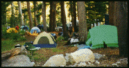
The trail now turns to a rocky dusty jeep road for about 3 or 4 miles. As we neared the Brockway Summit Highway 267 crossing, we were greeted by group one coming back up the trail towards us. They had felt that the trail was dropping down too far below the summit and were going back to a side trail up hill. We all followed to find it went up to the top of the hill and dead ended. We spent 1/2 hour there while the ride leaders tried to get some direction from the forest service by cell phone. We finally rode back to the road crossing some 2 miles to make sure the sign did say this was the TRT - and it did - and we retraced our original route down the hill and did find the highway crossing. Some 7 miles later we reached our destination, Watson Lake (7900 ft.), a small beautiful alpine lake with great camping spots, no road or highway noise, only coyotes howling in the distance.
 Just
after dinner we heard a call for help - Dean Wilson's horse had
gone down and appeared to be unconscious. We all yelled and kicked
and lifted and did finally get the horse up on his feet, covering
him with a multitude of blankets. Efforts to find a veterinarian
by cell phone were futile. 911 got some help from Placer County
Sheriff office who secured a vet and led him to our location.
The horse was treated by the vet and recovered but did not continue
on the ride.
Just
after dinner we heard a call for help - Dean Wilson's horse had
gone down and appeared to be unconscious. We all yelled and kicked
and lifted and did finally get the horse up on his feet, covering
him with a multitude of blankets. Efforts to find a veterinarian
by cell phone were futile. 911 got some help from Placer County
Sheriff office who secured a vet and led him to our location.
The horse was treated by the vet and recovered but did not continue
on the ride.
We again drew night watch - had to untangle some horses and tighten the high line during our 2 hour stint (2:00 a.m. to 4:00 a.m.). Again we had a nice fire and a beautiful starry sky.
Day Seven:
We are headed for Tahoe City around Mt.
Watson, past Painted Rocks with beautiful vistas south to Carnelian
Bay and Dollar Point. At what is called Cinder Cone we were forced
to dismount and lead the horses because of the rocks.  This
section of the trail is just a jumble of sharp angular rocks
for 3/4 mile. Then the descent down to Tahoe City, watered the
horses at the fire house and then to cross the traffic packed
highway and the Truckee River Bridge. The sight of the many horses
was a traffic stopper. Many stepped out of their cars to take
photos. We proceeded a few blocks along Highway 89 turning off
toward the Granlibaken Ski Center through Paige Meadows and down
to Ward Creek (6900 ft.) where camp was set up between the road
and Ward Creek. At campfire George Cardinet read some Robert
Service Poems. Nancy Dupont announced that the next day's ride
had been pre-ridden by 1982 National Endurance Champion, Brenda
Ruedy and her friend Becky Drancy who would lead group one. That
was good news - we found later that they had only pre-ridden
half of the trail distance a month ago.
This
section of the trail is just a jumble of sharp angular rocks
for 3/4 mile. Then the descent down to Tahoe City, watered the
horses at the fire house and then to cross the traffic packed
highway and the Truckee River Bridge. The sight of the many horses
was a traffic stopper. Many stepped out of their cars to take
photos. We proceeded a few blocks along Highway 89 turning off
toward the Granlibaken Ski Center through Paige Meadows and down
to Ward Creek (6900 ft.) where camp was set up between the road
and Ward Creek. At campfire George Cardinet read some Robert
Service Poems. Nancy Dupont announced that the next day's ride
had been pre-ridden by 1982 National Endurance Champion, Brenda
Ruedy and her friend Becky Drancy who would lead group one. That
was good news - we found later that they had only pre-ridden
half of the trail distance a month ago.
Day Eight:
Found us crossing Ward Creek and immediately climbing 2100 feet to Twin peaks (8898 ft.). Much of this trail is old jeep roads until we get near Stanford Rock where the trail becomes very faint and traverses a large rock slide where we lead our horses. From Stanford Rock to Twin peaks was a short connector trail allowing thoroughfare on to the Pacific Crest Trail (PCT) and into the Granite Chief Wilderness Area. The Connector Trail had been built by George Cardinet a few years back, bypassing an awful trail down into Blackwood Canyon.
 Once
on the PCT we stopped for a long photo session of vistas to the
west and south. We hadn't gone but a mile or so on the PCT and
we were confronted with blockage by a 4 foot diameter tree downed
on the trail. Group one had ribboned their detour straight down
a very steep slope that was now all loose dirt. Travel was forced,
Snowy River Style, then came a few hundred feet of dense waist
high brush. Next was the rock slide where again we lead our horses
- too rough to ride. We finally found our way back up to the
trail and had lunch in a very pleasant mountain meadow.
Once
on the PCT we stopped for a long photo session of vistas to the
west and south. We hadn't gone but a mile or so on the PCT and
we were confronted with blockage by a 4 foot diameter tree downed
on the trail. Group one had ribboned their detour straight down
a very steep slope that was now all loose dirt. Travel was forced,
Snowy River Style, then came a few hundred feet of dense waist
high brush. Next was the rock slide where again we lead our horses
- too rough to ride. We finally found our way back up to the
trail and had lunch in a very pleasant mountain meadow.
 After
lunch, we continued south on the PCT. Again the trail traversed
a very steep side hill of small loose shale and gravel. The actual
trail width at times was no wider than 12 inches, simply because
it was so steep - everything would just roll down the mountain.
The usual trail chatter seemed to hush... You would hear "Oh
my God!" or "just look toward the bank.".... Then
we came upon a tree down across this section of the trail. We
had to go down, around and back up to the trail. Some didn't
think they could do that, but all did. Our horses handled it
well and willingly. There were some questions at this point about
the pre-ride comment the night before. Some decided they would
not continue on this adventure after this day's ride. One timely
remark was "Gee, that would have been an "E" ride
ticket at Disneyland!". That comment brought some laughter
and eased the nerves and tension among the group.
After
lunch, we continued south on the PCT. Again the trail traversed
a very steep side hill of small loose shale and gravel. The actual
trail width at times was no wider than 12 inches, simply because
it was so steep - everything would just roll down the mountain.
The usual trail chatter seemed to hush... You would hear "Oh
my God!" or "just look toward the bank.".... Then
we came upon a tree down across this section of the trail. We
had to go down, around and back up to the trail. Some didn't
think they could do that, but all did. Our horses handled it
well and willingly. There were some questions at this point about
the pre-ride comment the night before. Some decided they would
not continue on this adventure after this day's ride. One timely
remark was "Gee, that would have been an "E" ride
ticket at Disneyland!". That comment brought some laughter
and eased the nerves and tension among the group.
On to Barker Pass which is a major trail head to the PCT, elevation 7760 ft., complete with fancy new restrooms that we found ...locked. Because a bridge wash-out closed the road to Barker Pass, we had to travel about 4 miles down old Barker Pass Road now just a dusty jeep road to the camp at Blackwood Canyon, a drop of 1400 feet. Here we camped near Blackwood Creek. Next to our camp was an old gravel pit half filled with water where we watched a large adult beaver bring branches of aspen down the bank, swim across the pond and submerge to his underwater home.
At dinner our group was blessed with a horseman's celebrity, none other than Doni Hubbard, author of such fine trail guide books as "New Trail Adventures", "Favorite Trails of Northern California Horseman" and "Favorite Trails of the Desert". Doni rode with us for three days - all enjoyed her many trail side tales.
Day Nine:
Back up the jeep trail to Barker Pass.
Today's travel will be on the PCT south with destination, Bayview,
a distance of 24 miles. This section was where the forest service
had cut 110 downed trees in anticipation of our trip. The grade
was gentle and very scenic. We lunched at Richardson Lake. 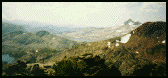 Just south of Richardson Lake we
enter Desolation Wilderness Area. This first section, in contrast
to the bulk of this wilderness, is heavily timbered. Not until
we reach Middle Velma Lake do we see the open solid granite terrain
the wilderness is noted for.
Just south of Richardson Lake we
enter Desolation Wilderness Area. This first section, in contrast
to the bulk of this wilderness, is heavily timbered. Not until
we reach Middle Velma Lake do we see the open solid granite terrain
the wilderness is noted for.
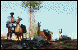 We met
a woman with a large llama, hiking from Mexico to Canada. Near
Middle Velma we met a group of Pacific Crest Trail Maintenance
Volunteers packing in with eight llamas. From near Middle Velma
Lake on, the trail became all granite, solid slab granite with
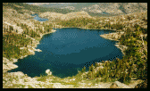
lots of step ups and step downs. Here we left the PCT and dropped
down 2150 feet on what seemed like 100 switch backs. We had spectacular
views to Emerald Bay, Granite and Cascade Lake. The Bayview Camp
site had 4 large pipe rail corrals available but we were told
that we couldn't use them because they were expecting a string
of 20 pack mules in that evening (which never arrived). This
was probably the worst campsite (for this large a group) of all
experienced on this ride. Tent sites were all side hill, not
much open space to high line our horses, many just tied their
horses to the outside of the corrals. There was no water until
mid evening - it was trucked in large garbage cans.
We met
a woman with a large llama, hiking from Mexico to Canada. Near
Middle Velma we met a group of Pacific Crest Trail Maintenance
Volunteers packing in with eight llamas. From near Middle Velma
Lake on, the trail became all granite, solid slab granite with
lots of step ups and step downs. Here we left the PCT and dropped
down 2150 feet on what seemed like 100 switch backs. We had spectacular
views to Emerald Bay, Granite and Cascade Lake. The Bayview Camp
site had 4 large pipe rail corrals available but we were told
that we couldn't use them because they were expecting a string
of 20 pack mules in that evening (which never arrived). This
was probably the worst campsite (for this large a group) of all
experienced on this ride. Tent sites were all side hill, not
much open space to high line our horses, many just tied their
horses to the outside of the corrals. There was no water until
mid evening - it was trucked in large garbage cans.
Day Ten:
The last day of our adventure and one
of the most scenic rides. Really different from what we have
seen the last 9 days. So it's up the mountain, past Granite Lake
and connecting again with the PCT, we climb on hemlock lined
switch backs, a 3300 foot climb to the top, Decks Pass (9380
ft.), the highest pass in Desolation Wilderness. 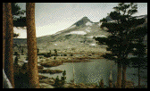 We
get far ranging views both north and south. We find a large bank
of snow on this almost level area where clusters of dwarfed wind
trimmed conifers mark the edge. Our three Peruvian horses get
acquainted with the snow by foot and mouth. At this spot there
was considerable concern by our leaders to which trail we were
to take which puzzled some of us because the map only shows one
trail. So down the mountain where we encountered some brilliant
wild flower displays, exhibiting the spring season during late
August at 9000 feet.
We
get far ranging views both north and south. We find a large bank
of snow on this almost level area where clusters of dwarfed wind
trimmed conifers mark the edge. Our three Peruvian horses get
acquainted with the snow by foot and mouth. At this spot there
was considerable concern by our leaders to which trail we were
to take which puzzled some of us because the map only shows one
trail. So down the mountain where we encountered some brilliant
wild flower displays, exhibiting the spring season during late
August at 9000 feet. 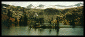 We
soon took a side trail and lunched at Lake Gilmore, then on to
Susie Lake and Heather Lake where the trail skirted the shoreline.
Next came Lake Aloha - this lake has hundreds of dead tree snags,
a result of raising the water level - across the lake we see
Pyramid Peak. At this point the skies were showing signs of a
storm - clouds, gray and dark - temperature dropping. Ruth had
carried her waterproof coat for nine days and seldom took it
off the saddle while on the trail. So this morning she decided
to pack the coat with the other gear that was loaded into the
truck. Soon the thunder clapped and the lightening flashed. The
wind picked up and .... it poured. I gave Ruth my oiled canvas
coat, Cheri gave me her extra windbreaker (not waterproof). Then
it began to snow - it stormed for an hour - but we kept moving.
The horses showed their disdain with ears back.
We
soon took a side trail and lunched at Lake Gilmore, then on to
Susie Lake and Heather Lake where the trail skirted the shoreline.
Next came Lake Aloha - this lake has hundreds of dead tree snags,
a result of raising the water level - across the lake we see
Pyramid Peak. At this point the skies were showing signs of a
storm - clouds, gray and dark - temperature dropping. Ruth had
carried her waterproof coat for nine days and seldom took it
off the saddle while on the trail. So this morning she decided
to pack the coat with the other gear that was loaded into the
truck. Soon the thunder clapped and the lightening flashed. The
wind picked up and .... it poured. I gave Ruth my oiled canvas
coat, Cheri gave me her extra windbreaker (not waterproof). Then
it began to snow - it stormed for an hour - but we kept moving.
The horses showed their disdain with ears back.
 We
soon could see Echo Lakes, both upper and lower. We traveled
a roller coaster trail high above the shore line. At the south
end, the grocery did a brisk business as we passed. At this point,
another two miles put us at the Highway 50 crossing where they
put one of the horses out on the yellow line (middle of the road).
We
soon could see Echo Lakes, both upper and lower. We traveled
a roller coaster trail high above the shore line. At the south
end, the grocery did a brisk business as we passed. At this point,
another two miles put us at the Highway 50 crossing where they
put one of the horses out on the yellow line (middle of the road).
 This stopped all traffic
and everyone crossed this heavily traveled high-speed roadway
safely.
This stopped all traffic
and everyone crossed this heavily traveled high-speed roadway
safely.
Another mile put us back where we had started 10 days ago. We all had a wonderful banquet - champagne and all to celebrate out return.
After 8 hours on the trail, 21 miles of rough rocky trail, everyone was ready to turn in early and not have to worry about packing up the tent, etc. the next morning.
Our 10 day adventure was complete.
Compliments and Thanks are extended to the Heritage Trail Fund Program which allowed us to be able to enjoy the breathtaking beauty during our ten day ride!
Return
to Ten Day Ride Page One
Return
to Pasos on the Web!
Visit the TAHOE RIM TRAIL Web Site
This page created and
placed by Pasos on the
Web!
Last Update made June 14, 1999